


Analysis
While Spain bakes, Britain is catching a chill – but summer 2023 could be a scorcher
The last eight years have been the warmest on record – and weather patterns are becoming more likely to fix in position for prolonged periods. But temperatures this year could be super-charged by the flipping of a massive ocean current in the Pacific Ocean, El Niño.
Thomas Moore
Science correspondent @SkyNewsThomas
Tuesday 25 April 2023 22:22, UK

Listen to this article
0:00 / 3:04
1X
BeyondWords
Audio created using AI assistance
Tom Cheshire1:59
Play Video – Spain could hit 40C this month
Spain could hit 40C this month
Why you can trust Sky News
It may only be spring, but Spain is already feeling the heat.
Temperatures could reach a new April high later this week – perhaps even peaking at 40C, which would smash the previous record of 37.4C set in 2011.
Areas like Andalucia in the south and inland Cordoba are expected to be the hottest with temperatures 15C higher than average for the time of year.
But even coastal areas such as Gibraltar could be 10C warmer than normal.
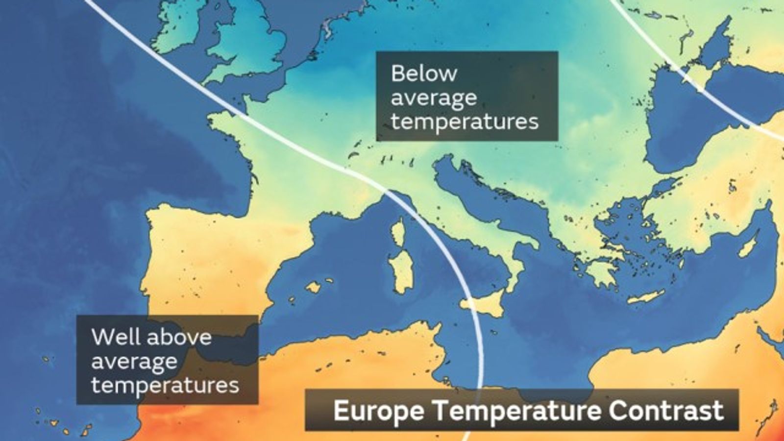
Met Office map showing the temperature contrast in Europe.
Image:
This Met Office map shows the contrast in temperatures across Europe
It’s partly because of weather patterns that are pumping hot, dry air north from the Sahara.
The skies over Spain are also clear blue, increasing the amount of the sun’s radiation reaching the ground.
And the soil is extremely dry in many regions after months of drought, which means there is little water evaporating from the ground to cool the air.
While Spain bakes, Britain is catching a chill.
According to the Met Office temperatures in the UK, particularly the north, are around 6C cooler than normal for the time of year.
Check the five-day weather forecast for where you live
A cold blob is sitting over much of northern Europe as a low pressure system moves east and draws Arctic air south.
The jet stream is a core of strong winds around 5 to 7 miles above the Earth’s surface, blowing from west to east.
Image:
The jetstream is a core of strong winds around 5 to 7 miles above the Earth’s surface, blowing from west to east. Pic: Netweather.tv
It’s quite a contrast, with the high-altitude winds of the jetstream marking the current border of hot and cold air as they race across the Bay of Biscay and France.
What does all this mean for the summer?
Well, this will be Spain’s second extreme heatwave of the year – already.
Temperatures in January also broke records for the time of year, with Bilbao passing 29C. Beach weather in mid-winter.
And with the soil so dry and the coastal seas so warm there is a good chance of more monthly records falling.
Pic:AP/PA
Image:
Pic: AP/PA
The UK is also expected to warm up. The National Drought Group has warned water companies and consumers to prepare for a hot, dry summer.
The driest February in 30 years and the wettest March in 40 shows just how variable our weather has become.
Devon, Cornwall and East Anglia are still, officially, in drought. And a hosepipe ban has now been extended to people living in the Roadford area of the South West.
Climate change lies behind such unpredictability. The last eight years have been the warmest on record – and weather patterns are becoming more likely to fix in position for prolonged periods.
Temperatures this year could also be super-charged by the flipping of a massive ocean current in the Pacific Ocean.
The phenomenon is called El Niño and is natural. But it results in massive amounts of extra heat that’s stored deep within the ocean being released into the atmosphere, adding to the effect of greenhouse gases.
It could mean 2023 will be a scorcher.


")
")


